[meteorite-list] 6 crater fields in central New Mexico:
From: Paul H. <oxytropidoceras_at_meteoritecentral.com>
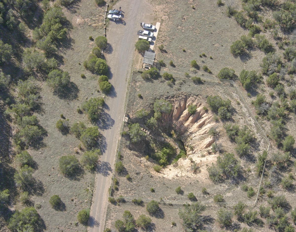
Date: Mon, 11 Jul 2011 9:37:05 -0500 Message-ID: <20110711103705.YE0SD.123811.imail_at_eastrmwml28> In ?[meteorite-list] 6 crater fields in central New Mexico: Dennis Cox: Rich Murray 2011.07.09 at http://six.pairlist.net/pipermail/meteorite-list/2011-July/078188.html Rich Murray wrote: ?6 crater fields in central New Mexico: Dennis Cox: Rich Murray 2011.07.09 http://craterhunter.wordpress.com/ A Catastrophe of Comets More New Mexico Craters Rich Murray: I slightly adjusted the view locations. They sure look like impact craters... ? No they do not look like meteorite craters. First, these featrues lack the morphology, which would suggest that they might be meteorite craters. The majority lack the circular or elliptical outline that might characterize an impact crater. The majority of them are far to irregular to be candidates for impact craters. In addition, sinkholes can also have nice circular outlines as can be seen in the Bottomless Lakes of Bottomless Lakes State Park about 14 miles southeast of Roswell, New Mexico. The Bottomless Lakes are discussed at: Bottomless Lakes State Park, New Mexico http://www.emnrd.state.nm.us/PRD/bottomless.htm Kottlowski, F. E., 1979, Bottomless Lakes: New Mexico Geology, vol. 1, pp. 57-58. McLemore, V. T., 1999, Bottomless Lakes: New Mexico Geology, vol. 21, no. 2, p. 51-55. http://geoinfo.nmt.edu/tour/state/bottomless_lakes/home.html Rawling, G., and D. J. McCraw, 2010, Geologic map of the Bottomless Lakes quadrangle, Chaves County, New Mexico. Open-file geologic map. no. 126. scale 1:24,000, New Mexico Bureau of Geology and Mineral Resources. Socorro, New Mexico. http://geoinfo.nmt.edu/publications/maps/geologic/ofgm/details.cfml?Volume=126 Second, if a person looks at the regional topographic maps, these features lack any sign of the rim that an impact crater would typically have. Finally, geologists have looked at these features and found them to be classic examples of carbonate karst, which are developed in the alternating layers of limestone and dolomite of the San Andres Formation, which underlies this area. What one of these sinkholes looks like near the ground surface can be seen the web page for Fort Stanton Cave, Lincoln County, New Mexico, at http://www.fscsp.org/photos/entrance_aerial_view_1200.jpg http://www.fscsp.org/ The cave is located at lat. 33.50673?, long. -105.4936248? about 28 miles south of the above area of karst. I have talked about these features before in: [meteorite-list] Impact Crater in New Mexico ? Part 2 Lincoln County Revisited, January 6, 2009, http://six.pairlist.net/pipermail/meteorite-list/2011-January/072231.html A couple of web pages: Karst http://en.wikipedia.org/wiki/Karst Sinkhole http://en.wikipedia.org/wiki/Sinkhole There might be an impact crater or few lost among all of these sinkholes. However, distinguishing them from the sinkholes and demonstrating that they are impact craters will take a lot a field work. It is certainly something that will be impossible to do simply from aerial imagery. Rich Murray wrote: ?Ground samples may reveal evidence of blast and surface melting and coating.? A person can look if they want. I suspect that it such a search will find a complete absence of any credible evidence ?blast and surface melting and coating.? If a person wants to look for features to investigate as possible impact craters, they can check out a reported possible impact crater by Skotnicki (2009) within the Lincoln 7.5 quadrangle, Lincoln County, New Mexico. The reference is: Skotnicki , S. J., 2009, Preliminary Geologic Map of the Lincoln Quadrangle, Lincoln County, New Mexico. scale: 1:24,000. Open?file Digital Geologic Map OF?GM 188. New Mexico Bureau of Geology and Mineral Resources, Socorro, New Mexico. http://geoinfo.nmt.edu/publications/maps/geologic/ofgm/details.cfml?Volume=18 8 http://geoinfo.nmt.edu/publications/maps/geologic/ofgm/downloads/188/Lincoln_Rep ort.pdf http://geoinfo.nmt.edu/publications/maps/geologic/ofgm/downloads/188/Lincoln_v1p -00.pdf Rich Murray wrote: ?69 views are in: https://www.dropbox.com/gallery/2268163/1/CraterField?h=c40610 A Cox 34.281890 -105.139342 1.755 km area el just S of County Road 3Ka, which comes from 10M SW of 285 and then W and N to 54, 60, 285 just W of Vaughn -- 22 M S of Vaughn 75 M NNW of Roswell many craters .01 to 0.1 km size? No craters. Just craterwrongs in the form of sinkholes. Rich Murray wrote: ?B Cox 34.254942 -105.117973 10 M SW of 285 many craters? No craters. Just more sinkholes. Rich Murray wrote: ?C Cox 34.203891 -105.058533 1.674 km area el 9 M SW of 285 .05 km wide 4 m deep? Even more sinkholes. Rich Murray wrote: ?D Cox 34.191197 -105.027841 1.644 km area el 8 M SW of 285 .07 km size 13 m deep? Just another sinkhole. Rich Murray wrote: ?E Cox 34.207906 -105.02134 1.606 km area el 7 M SW of 285 .04 km wide 3 m deep? Just another sinkhole. 34.207906 -105.02134 ?F Cox 34.210453 -105.03963 1.645 km area el 8 M SW of 285 .05 km wide 4 m deep? More sinkholes. :-) Best wishes, Paul H. Received on Mon 11 Jul 2011 10:37:05 AM PDT |
|